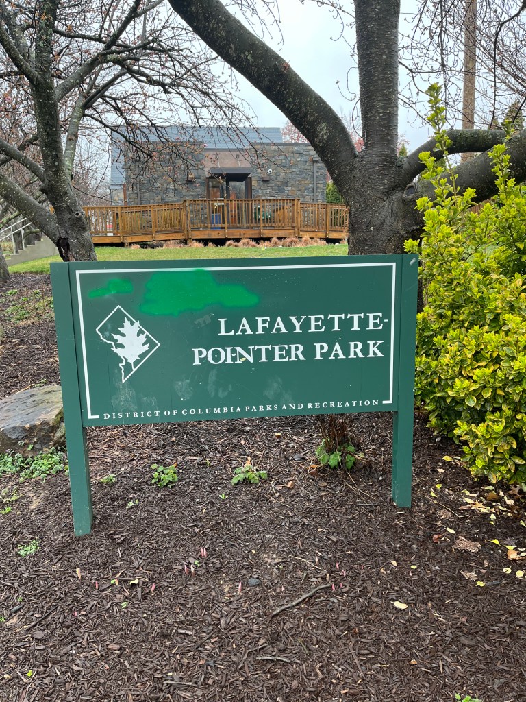
This past Saturday, March 25, 2023, following the DC History Conference, I was given a fascinating tour of the neighborhood in which I grew up by Carl Lankowski, President of the community organization Historic Chevy Chase DC. We concentrated on three remarkable signs unveiled in June 2021 by the organization, on the grounds of what is now known as Lafayette-Pointer Park, previously Lafayette Park, adjacent to Lafayette Elementary School, the institution which I attended, Kindergarten through Sixth Grade, that is to say, Fall 1966 through Spring 1973.
The project is summarized at
https://www.historicchevychasedc.org/category/lafayette-pointer-project/
When I attended Lafayette, the school and the neighborhood were overwhelmingly white. Until a few years ago, I had not realized that these circumstances, as the organization puts it, exemplified “segregation by design.” For many properties in Chevy Chase DC (that is to say, the part of Chevy Chase south of Western Avenue, within the District of Columbia), restrictive covenants were in place, legally preventing sale of property to non-white owners. For other properties, softer barriers seem to have been operative to prevent residential diversity, including mortgage lending practices (“red lining”) and related social and economic pressures.
Most important, and shamefully, in 1928, DC municipal authorities, working closely with white civic leaders, acquired substantial land property from its historic African American owners, who had resided there in some instances for nearly eight decades, in order to establish the grounds of Lafayette Elementary School and Lafayette Park and playground, which were to remain essentially all white spaces for decades. This same set of legislative actions led to the acquisition of lands on which Alice Deal Junior High and Woodrow Wilson High schools would be constructed, based on the veritable ethnic cleansing of Reno City, a large and vibrant African American (and white) working class neighborhood near the site of the Civil War site Fort Reno.
Brooks Family Background
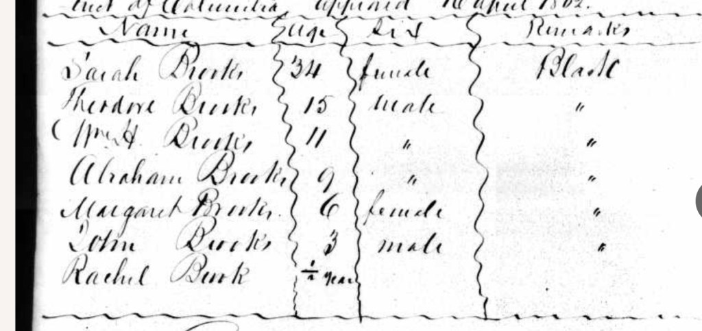
I began to become aware of this history several years ago, as I was tracing the history of the Brooks family, who had been enslaved, by the white Nourse family on the grounds that later became the Washington National Cathedral and Sidwell Friends School. Sidwell, as it happens, is where i attended High School, several years after graduating from Lafayette. As I have written elsewhere, Sarah Brooks and her children, Theodore, William Henry, Abraham, Margaret, John, and Rachel, were all enslaved by Charles Josephus Nourse and Charles’ wife Rebecca Morris Nourse. At some point in the late 1850s it appears, Sarah’s husband William Brooks purchased the freedom of his wife and their children.
William, so far as I can tell, was purchased with his mother Ann and his siblings in 1827, by Joseph Nourse, the first Registrar of the US Treasury, who was the father of Charles Josephus Nourse. William evidently acquired his freedom before the enumeration of the 1850 census, when he is listed as a free man of color, working as a coachman, residing at the Nourse plantation known as the Highlands, the future site of the Sidwell Friends middle and upper schools.
As I’ve written, the 1860 census enumerates Sarah Brooks and her children as free people of color, residing at the Highlands, in the household of Rebecca Nourse, widow of the late Charles Josephus Nourse. Yet, in 1862, William Brooks petitioned for compensated emancipation for his wife Sarah and their six children under the terms of the DC Emancipation Act. Presumably, while the Nourses allowed the Brooks family to be listed as free in the 1860 census as free, Saran and her children had not yet officially been manumitted, so William Brooks, who must have previously purchased them from the Nourses, took advantage of the Emancipation Act to free his wife and offspring formally and petition for some payment.
After Emancipation, Sarah Brooks continued to work at the Highlands as the cook. Before the Civil War, William and Sarah Brooks had worshipped at Saint Alban’s Episcopal Church, a church closely associated with the Nourse family on the Mount Albans property. From 1861 onwards she worshiped at First Methodist Episcopal Independent Church, and remained a member until her death on 18 May 1875 She was buried in Mount Zion Cemetery in Georgetown. (Some of this research is summarized in an article in the Washingtonian Magazine). Members of the Brooks family appear in an 1885 photograph taken behind Zartman House, the old Highlands manor house, now in the Sidwell Friends Archives.
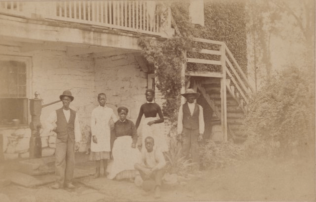
Showing “Rachel Brooks, dook,” her daughter, and other African American staff memebrs. Sidwell Friends School Archives
Sarah and William Brooks’ son, William Henry Brooks (b 1851, died around 1903), at some point converted to Catholicism, and married Laura Dover, who grew up next door to the Brooks family in Tenleytown. north of the Highlands. They named their first born Francis (“Frank”) Denecker Brooks, evidently in honor of the Jesuit Father Francis Xavier Denecker (c. 1819-1879), who had some connections with Georgetown College.
Frank Brooks on 5 Feb 1896 married Mary Briggs. The couple initially lived in Reno City, which was, as noted above, a semi-autonomous African American community around the old Fort Reno, adjacent to Tenleytown. They may have resided in the home of Frank’s father William Henry Brooks. By 1900, Frank and Mary and their children had moved to Rock Creek Ford Road, a couple of miles east of Reno City. They resided next door to the father of Mary Briggs Brooks, William Briggs.
Mary died at some point between 1903 and 1910, and Frank continued to reside on Rock Creek Ford Road until at least 1912. (Currently Rock Creek Ford Road is east of Rock Creek Park, but I assume that around the turn of the century it ran across Rock Creek, as the name suggests.) I explore some of this history in my essay “Traveling Together.“
The Brooks on Broad Branch Road
Franks Brooks remarried on 13 Dec 1913, to Sarah J. Gravett, who assisted in raising Frank’s young motherless children. By 1917, the couple was living on Broad Branch Road, on the property where they would reside for the next eleven years. I am not as of this writing sure if they purchased land, or were renting, perhaps from members of the Harris family, the African Americans who long owned farmland along Broad Branch, on the land that would later become Lafayette-Pointer park. (Many members of the Harris family are buried in Mount Zion Cemetery, where Sarah Brooks, the grandmother of Frank Brooks, is also interred.)
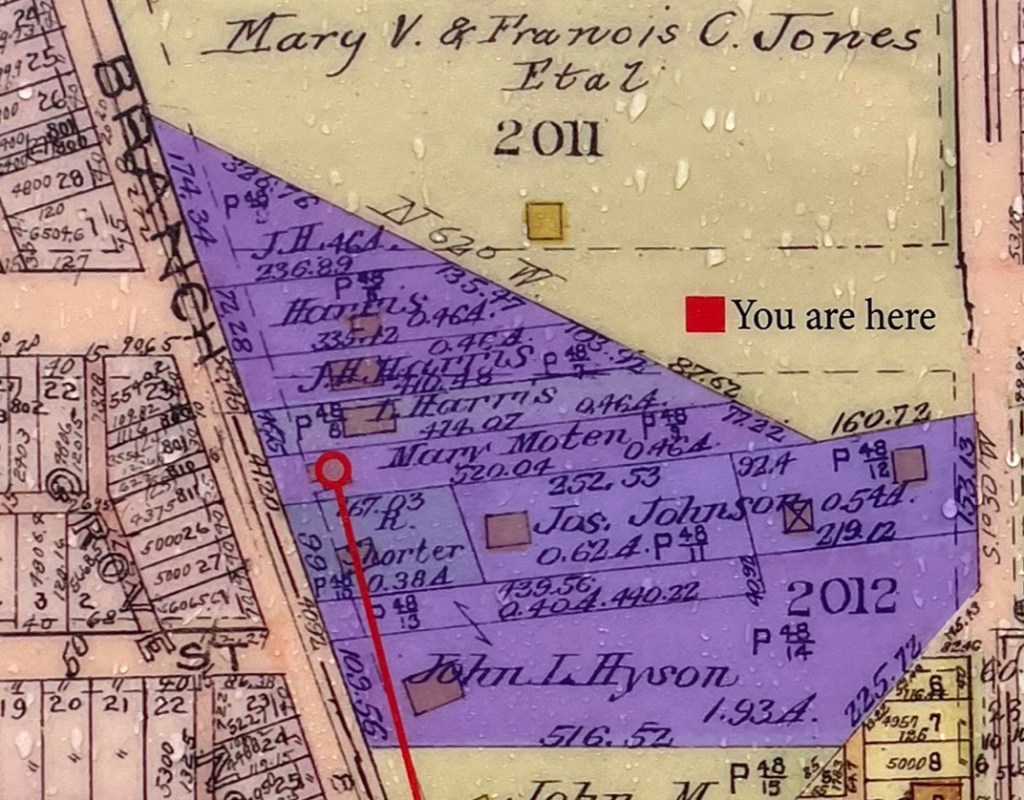
The 1919 Baist Atlas depicts the 6 acre plot of Black-owned land along Broad Branch Road in purple. Land owners listed include P. Harris, J.H (Joseph) Harris, D. Harris, Mary Moten (the daughter of Mary Harris), R (Richard) Shorter, James Johns, and John L. Hyson. There does not appear to be an indication of the Brooks family on this property map.
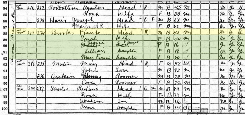
However, the next year the 1920 census records Frank and Sarah Brooks residing on Broad Branch with Frank’s children by his previous marriage to Mary Briggs Brooks, Mary Francis Brooks (b 1900) Lillian Brooks, (b 1902), and Bessie Brooks (b. 1904). The Brooks are listed just between Joseph Harris and Mary Moten, which might imply, based on the 1919 Baist Map, that they were living on the property of D. Harris, about halfway between Patterson and Oliver Streets, on the east side of Broad Branch Road.
The 1928 city directory records a street address for Frank and Sarah, at 5819 Broad Branch Road. (A 1929 Washington Post article lists Mary Moten’s address as 5803 Broad Branch Road).
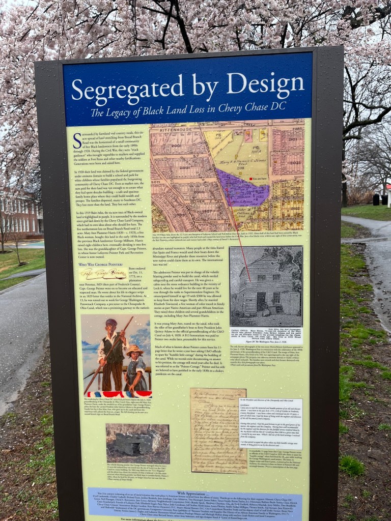
We do know that in 1928, the District of Columbia authorities exercised eminent domain to acquire all six acres of this black-owned land, to establish the twelve and a half acre property on which would be built Lafayette Elementary School and Lafayette Park. Frank and Sarah Brooks at this point must have been forced off of the land where they had resided since at least 1917.
The 1930 census records Frank and Sarah in the Washington township of Falls Church, Virginia, where they would continue to live up until Sarah’s death in 1963. Frank’s great granddaughter, Bettye Howe Saunders, visited Frank at this farm property when she was young, and does not recall him ever discussing his time on Broad Branch Road. After Sarah’s death, Frank moved to Baltimore to spend his final years with his daughter Lillian.
Acknowledging Historic Injustice: the Lafayette-Pointer Interpretive Signs
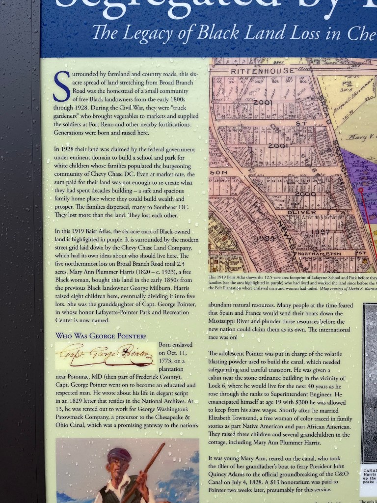
As noted, community activists campaigned in recent years to rename Lafayette Park, Lafayette Pointer park, honoring Captain George Pointer, born enslaved in 1779, whose granddaughter and other descendants settled in the Broad Branch Road property. With City Council approval, they succeeded in erecting three historical signs on the park property in June 2021.
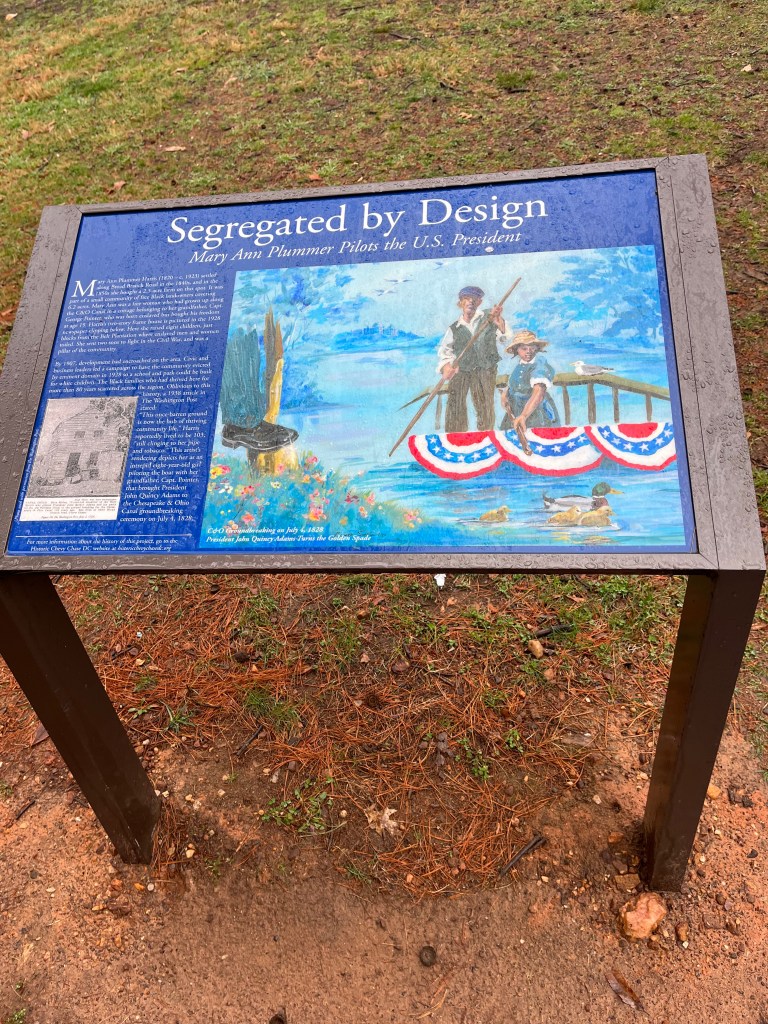
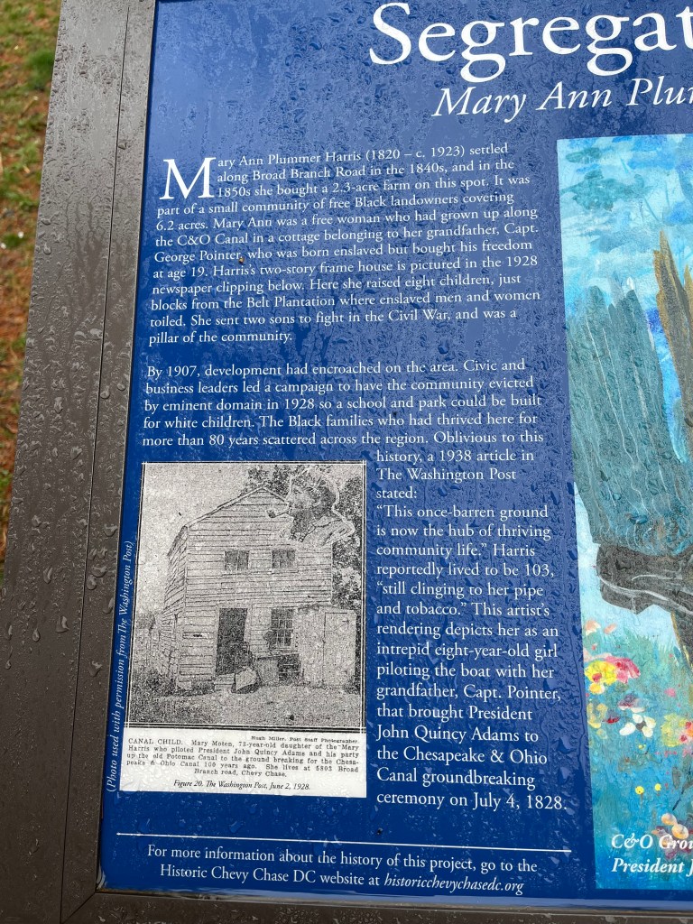
A sign overlooking Broad Branch Road features a commissioned artist’s rendition of the moment on July 4, 1828, when Mary Plummer Harris and her grandfather Captain George Pointer, piloted President John Quincy Adams to the groundbreaking of the Chesapeake and Ohio Canal. Mary Plummer Harris, the accompanying text notes, in the 1850s purchased a 2.3 acre farm, “on this spot.” The sign also reproduces a 1928 photograph of Mary Harris’ granddaughter Mary Moten sitting in front of her nearby house.

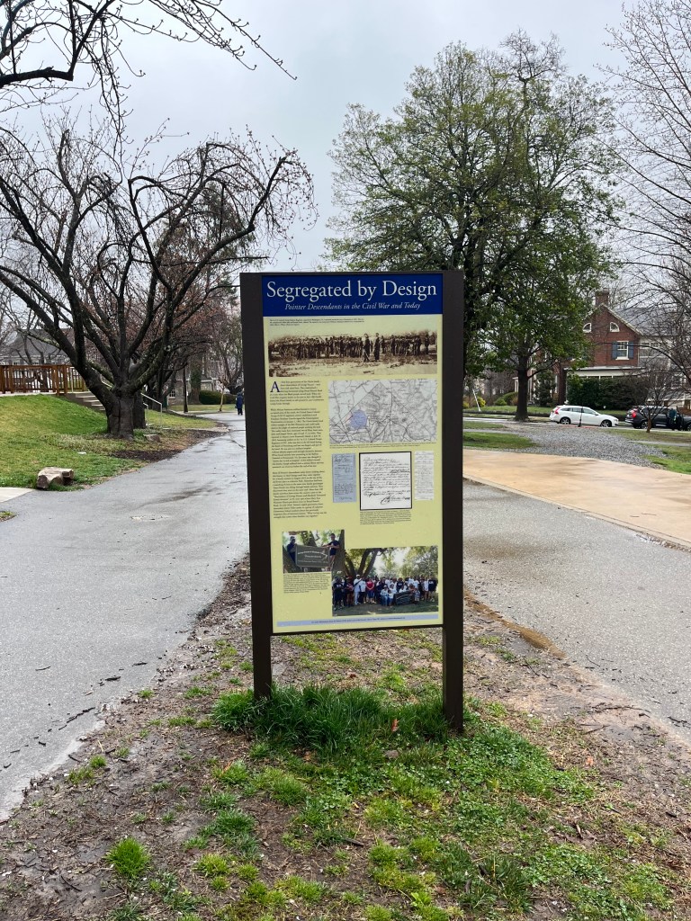
A more detailed two-faced sign, also bearing the title, “Segregated by Design,’ was placed in about 100 feet to the east of the first sign, in front of the Park’s recreation center, near 33rd street. The west facing side recounts the history of four generations of the African American Harris family, descended from Captain George Pointer, including the military service of brothers John Harris and George Harris in the 1st Colored Troops Regiment of Washington DC during the Civil War. The sign at its base reproduces a striking photograph of the August 2015 reunion of Pointer family descendants on this land,
The east facing sign explores in more detail the legacies of Black land loss in Chevy Chase DC neighborhood, including the dispersal after 1928 of Harris family members, many to southeast DC. Much of the sign’s text is devoted to the life of George Pointer, based on a detailed petition he submitted in 1828 to safeguard his imperiled house along the C & O Canal.
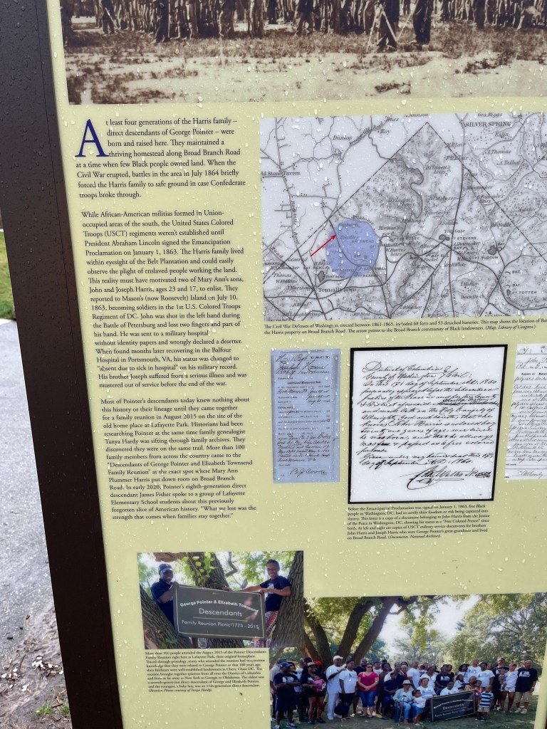

The signs are wonderful, but I note that they have no mention of the family of Frank Brooks, which was also severely impacted by the coercive 1928 land dispossession process. Perhaps, in consultation with Frank Brooks’ descendants, interpretive signage will be developed and erected to honor their family’s history on this property
Slavery in the Neighborhood
Until Carl gave me the walking tour this weekend, I simply had not realized that Colonel Joseph Belt, (1680-1761), the major slaveholder and landowner in the area, had built in 1725 his Chevy Chase Manor House on what is now Oliver Street, a half block away from the house I grew up in (5807 Chevy Chase Parkway). On January 12, 1721,Colonel Belt received a patent from the estate called Chevie Chase 550 acres that eventually expanded to 1,000 acres. The region’s name inspired by Cheviot Hills, the boundary zone between England and Scotland; Chase may have seem appropriate given the hunting opportunities of this zone in the early 18th century. Belt, who married a daughter of Ninian Beall in 1707 was a significant slaveowner. His 1761 will names a number of enslaved people, as follows:
“In his will, “…Joseph leaves these named slaves: To his wife, males Sango, Batchelor, Wall, Bob, and Nero; and females Sarah with her children Jenny and Flora, another Jenny, Bess, Nan with her son Charles, plus a boy named Juba. He leaves his son Humphrey adult slaves named Rochester and Tom and boy slaves named Batchleor and Sango. To his grandson Joseph Sprigg, for the use of Sprigg’s mother Rachel, he leaves slaves James (adult man), Toby (boy), Babb (adult woman), and Babb (girl), said slaves to go to grandsons Osborn and Thomas sprig after Rachel’s death. To his son Tobias Belt, Joseph leaves slaves named Hercules and Toby, both adults. To his grandson Richard Belt son of Jeremiah, he leaves a slave girl named Jenny. To his grandson Thomas Belt son of Joseph, he leaves a girl named Pegg and a man named Shrewsbury. To William Belt (grandson?) he leaves a girl named Jenny and a boy named Sam. The will states that his remaining slaves are to be divided among several of his children.”
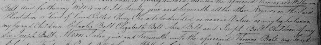
As of this writing, it is unclear which of these enslaved people labored on the Chevy Chase plantation. The will further specifies, “I hereby give and bequeath all other negroes on the said tract of land called Chevy Chase to be divided as near in value as may be between my grandchildren Charles Belt, Elizabeth Belt, Ann Belt, and Joseph Belt, children of my son Joseph Belt.” (Joseph Belt Jr appears to have died before Colonel Joseph Belt, Sr, and thus property was bequeathed directly to the grandchildren.)
Full will on Family Search at: https://www.familysearch.org/ark:/61903/3:1:33S7-9TYR-C3V?i=286&cc=1803986
Various tracts in Chevy Chase were bequeathed to his grandson Thomas Belt, son of Joseph (who, as noted above, received the slaves Pegg and Shrewsbury) and his grandson William Belt (who received the slaves Jenny and Sam). Thomas Belt moved at some point to North Carolina and died there, bequeathing several slaves to his heirs and requesting that the enslaved woman ‘June’ not be sold out of the family.
Perhaps future interpretive signage can honor these enslaved people, and others owned by successive generations of Belts, some of whom continued to work the land now known as Chevy Chase, both on the Maryland and District sides of the border.
Personal Reflections
My academic training was as an Africanist Anthropologist, and I did fieldwork for three years in a village in Eastern Zambia. I have been deeply engaged throughout my professional life in southern and central African history and worked a good deal on aspects of Afro Atlantic and African American history, including on the dynamics of the slave trade and the material culture of enslavement. Since the late 1990s, I have actively worked to document and commemorate local histories of enslavement and racial injustice in various locations across the United States, beginning in Georgia’s Newton County, around the site where Emory College, the forerunner of Emory University, was founded in 1836. My first book, The Accidental Slaveowner, traces the history of many African American families who, in slavery and freedom, helped to construct and care for Emory across the generations. Research on this book led me to trace the post-slavery experiences of Russell Nathan Boyd, who had been enslaved as a child by Bishop James Osgood Andrew, Emory’s first Board president, and who made a life for himself and his family in post Civil War Washington DC, becoming in time a respected librarian at the US Department of State. This work led me to reconstruct the story of enslaved people, many of whom had roots in Mount Vernon, and their labor quarrying the stones from which the first Smithsonian building (“The Castle”) was constructed. I’ve worked with my students on stories of enslaved people associated with Harvard College in Cambridge, Massachusetts, and more recently on slavery stories in the environs of what is now Mount Holyoke College, where i currently teach. I have also, as noted, collaborated with the Brooks-Howe family descendants and others to document the history of those enslaved on the grounds that later became Dumbarton House, Washington National Cathedral and Sidwell Friends School. More recently I have worked with the team at the Female Union Band Society and Mount Zion Cemetery in Georgetown, DC, to reconstruct the lives and legacies of families who loved ones are interred in that storied African American burial ground.
And yet, I most acknowledge that I never really gave any thought to the racial history of the Chevy Chase neighborhood, in which I resided from the age of four until nearly eighteen, that is to say from 1965 to early 1979. In hindsight, this seems to me remarkable. My parents were active in the Civil Rights movement, and we regularly attended anti war and Civil Rights demonstrations in DC and elsewhere.
Although Lafayette was an enormously white space while we attended elementary school, we had African American teachers whom we admired and we learned to sing “Lift Every Voice and Sing” from an early age. (Indeed, after leaving Lafayette, we were both surprised to discover that most white Americans were entirely unfamiliar with the song.) Although we did have a unit on African history at Lafayette, we certainly never learned about the nearby Belt plantation, centered on a Manor House a few doors away from our home, where generations of enslaved African Americans labored under unimaginably harsh conditions from the 1720s to the Civil War era. And we certainly never learned about the Harris and other African American families who had been property owners on the land of Lafayette Park, where we played and hung out from Kindergarten through Sixth Grade, and where I would later run though while practicing for Cross County during my high school years. Looking through my north-facing bedroom window on the third floor of our capacious house on Chevy Chase Parkway, I often would draw and paint the hilly landscape of the neighborhood, which I found enormously beautiful, never thinking that there might have been black landowners just up the hill, until 1928, just two years before my father Joe was born. As it happens, our alma mater at Lafayette began with the lines, “Long live our Lafayette/High on the Hill..” and I can’t help but wonder if those lyrics, by one of the school’s early music teachers, unconsciously were racially coded, celebrating the school’s geographical distinctiveness from the majority black city the existed to the east and south, at lower elevations.
I certainly knew nothing about the efforts by the white supremacist land developer Francis G. Newlands (to whom is dedicated the fountain in Chevy Chase Circle, adjacent to his old mansion, two blocks from our home) to create an entirely white trolley car suburb through the Chevy Chase Land Company. Historic Chevy Chase DC has also placed a sign, at the south end of Chevy Circle, documenting Newland’s racist land planning history.
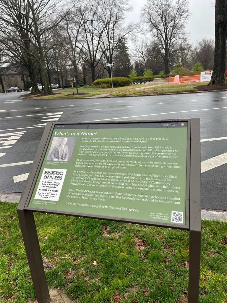
As it happens, The Maret School, the private school that I attended for 7th and 8th grades, immediately after graduating from Lafayette (and which my sister attended 7th through 12th grades) was located on the Woodley Estate. This was the former home of Francis G. Newlands, who moved there from his earlier house, at the intersection of Chevy Chase Circle and Western Avenue. The Woodley Mansion was constructed by the uncle of Francis Scott Key, Phillip Barton Key (d. 1815), who owned 12 enslaved people in 1810. Later the property was acquired by Union General Lorenzo Thomas, a slaveowner, who in April 1862, petitioned for compensated emancipation for his three enslaved people, the laundress Lucy Berry and her two small sons, George and Lorenzo, who had been held on the property.
Thus, all three K-12 institutions I attended in the District of Columbia’s northwest quadrant–Lafayette, Maret, and Sidwell Friends–had interconnected histories of enslavement and racial injustice, histories to which I was entirely oblivious until recently.
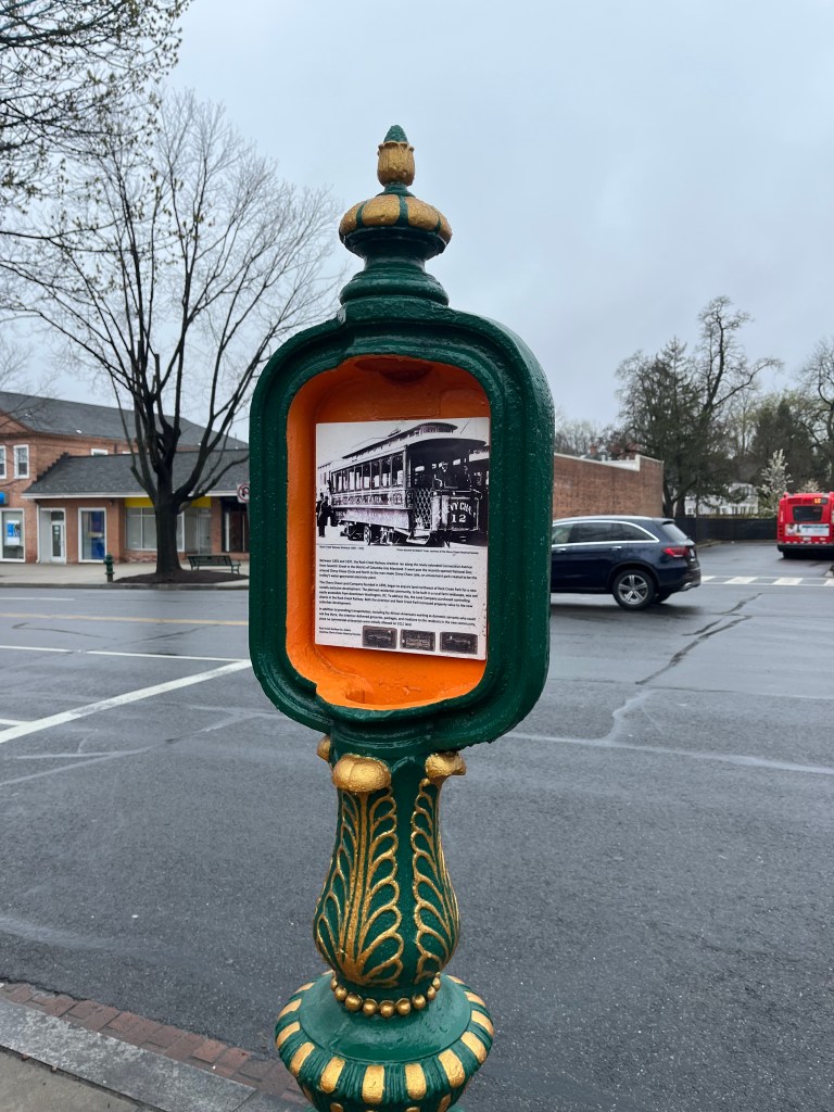
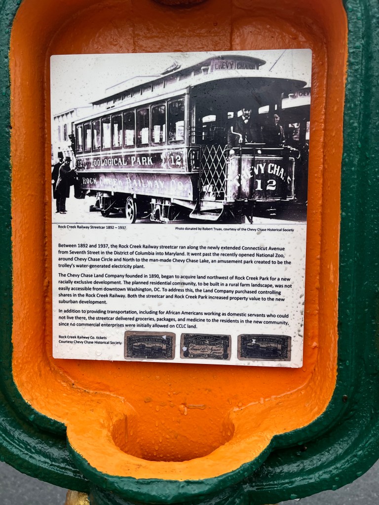
In hindsight, I am astounded by my own blindness to this history, since in the age of the internet, a few minutes of research could have so easily unearthed the actual history of black land ownership in Chevy Chase, actively racist zoning and housing practices, and earlier history of enslavement on these grounds. I take this blindness as emblematic of the conditions of un-reflective white privilege I was born and socialized into, which existed even in our avowedly progressive white secular Jewish family, a family that for over a century has thought of ourselves on the liberationist side of history. As a child I was certainly aware that Washington was a majority Black city, but most of the time this seemed a kind of distant fact. Nearby Rock Creek Park seemed a kind of, I am ashamed to say, a defensive perimeter, that safeguarded our very white neighborhood from the rest of the city, somewhere beyond its verdant quarters. (As Historic Chevy Chase DC’s signs at Chevy Chase Circle note, even the trolley car system served a racially informed function, bringing in during the day domestic servants of color who were not allowed to reside in the neighborhood.)
I’m enormously grateful to the activists and historians who have brought the history of Chevy Chase’s racial land dispossession to light, and who have thus forced me reckon with my earlier history of ignorance, in a sense willful ignorance, about a history of Black land ownership and dispossession on the landscape that I dearly loved growing up and that I continue to cherish. To be white in America while trying to be a person of conscience is to engage in a process of constant critical self reflection, slow step by slow step. Learning to see the land and places around us, especially the spaces that shaped us, through new eyes is a necessary part of that vital hard work. To see at long last the spaces of our childhood in a clearer way is to “come home” to a better place, to help call into existence a newer world that, while anchored in long histories of injustice, might just turn out, against the odds, to be a future refuge of compassion, tolerance, and truth-telling. Placing signs on the land in ways that honestly acknowledge histories of suffering and loss, is an important step along this long road towards the promised land.
